As I ended my adventures in Tha Khaek, I moved on further south in Laos – to Pakse (or Pakxe), located a bit less than 350 km away. The bus ride takes about seven hours, though. Pakse was made in 1905 by French as an administrative outpost. The city is located at the confluence of Mekong and Se Don (Don river) and is the capital of Champasak province. The city has quite attractive location – to the west there is Thai border, to the east there is the fertile Bolaven Plateau (famous for its coffee plantations and many waterfalls), to the south is the way to Si Phan Don (Four Thousand Islands). The construction of Lao-Japanese bridge on Mekong in 2002 sped up the city’s development thanks to faster connection with Thailand. The city itself is just another lethargic Mekong city – it is more about being than seeing, so there is not much to see in the city itself. It is the perfect base to visit Wat Phu Champasak complex or Bolaven Plateau.
On the first day of my stay here I have rented a motorbike and went on in the direction of Wat Phu Champasak. It is an ancient Khmer (so the same style as Angkor in Cambodia) religious complex, I think the largest one outside of Cambodia. In 2001 it was declared a UNESCO World Heritage Site. The complex spreads across 1400 m up to the lower slopes of Phu Pasak mountain range – 46 km away from Pakse. I got onto my freshly rented motorbike and hit the road. I followed the signs easily and everything looked nice until I have approached a small crowd of people. I asked for direction and was told that the main road is impassable, hence I have to take the small dirt path (on the photos). Intrigued by what was the reason behind all this, I stopped and came closer to the spot in which there should be a bridge – there I saw a reason for the road being impassable. The bridge was collapsed, and on what was left of it, in the valley there was a truck (just check out the photo!). The funny thing is, the trucks were in a convoy – the first one made it across the bridge but the second one wasn’t that lucky. The sign in front of the bridge said “No trucks with trailer” and “No vehicles over 15 T” – we can only guess how heavy the trucks were and for how long this ban was ignored by local drivers.
I continued my way then using the very local, narrow path (it’s hard to call it a road – see the photos) and happily arrived at Wat Phu Champasak. The site was worshipped since the 5th century but the remaining ruins are dated between 11th and 13th century. The entrance fee was about 5 euros (October 2014). Upon my arrival, it started to rain – luckily it stopped after some 30 minutes. It wasn’t heavy, but heavy enough to make photo taking really troublesome. In front of the ruins there are two large water ponds separated by the promenade. The ruins are quite well-preserved and are impressive – especially if you didn’t see the Angkok Wat in Cambodia. The location next to the mountain slope adds some charm. There are long stairs going uphill – and those stairs themselves make very interesting sight, especially in those places where trees are growing within them. At the top there are some objects connected to the site – like holy water spring, elephant stone or crocodile stone.
Before heading back I’ve noticed that my back tire was completely flat. In the village nearby I found the shop where a guy patched my tube for 1 euro. But upon arrival in Pakse there was almost no air left in the tube – I am not sure whether it was because of patching or I got a flat tire again – as I managed to return the motorbike before the tire went completely flat again.
From Pakse (A) to Wat Phu Champasak (or Vat Phou, B)

The reason why the main road to Wat Phu Champasak became impassable.
Przyczyna nieprzejezdności głównej drogi do Wat Phu Champasak.

A small path that led me to Wat Phu Champasak.
Lokalna ściezka, która zaprowadziła mnie do Wat Phu Champasak.

A small path that led me to Wat Phu Champasak.
Lokalna ściezka, która zaprowadziła mnie do Wat Phu Champasak.

Another river crossing point used by locals. The new bridge is under construction (on the right). On the way to Wat Phu Champasak, Laos.
Inny punkt przekraczania rzeki przez miejscowych. Po drodze do Wat Phu Champasak, Laos.

Another river crossing point used by locals. The new bridge is under construction (on the right). On the way to Wat Phu Champasak, Laos.
Inny punkt przekraczania rzeki przez miejscowych. Po drodze do Wat Phu Champasak, Laos.

Wat Phu Champasak, Laos

Wat Phu Champasak, Laos

Wat Phu Champasak, Laos

Wat Phu Champasak, Laos

Wat Phu Champasak, Laos

The stairs going uphill in Wat Phu Champasak – the nature’s property.
Schody prowadzące w górę na terenie Wat Phu Champasak – własność natury.

Wat Phu Champasak, Laos

The stairs going uphill in Wat Phu Champasak – the nature’s property.
Schody prowadzące w górę na terenie Wat Phu Champasak – własność natury.

Wat Phu Champasak, Laos

The stairs going uphill in Wat Phu Champasak – the nature’s property.
Schody prowadzące w górę na terenie Wat Phu Champasak – własność natury.

The stairs going uphill in Wat Phu Champasak – the nature’s property.
Schody prowadzące w górę na terenie Wat Phu Champasak – własność natury.

The stairs going uphill in Wat Phu Champasak – the nature’s property.
Schody prowadzące w górę na terenie Wat Phu Champasak – własność natury.

Wat Phu Champasak, Laos

Wat Phu Champasak, Laos

Wat Phu Champasak, Laos

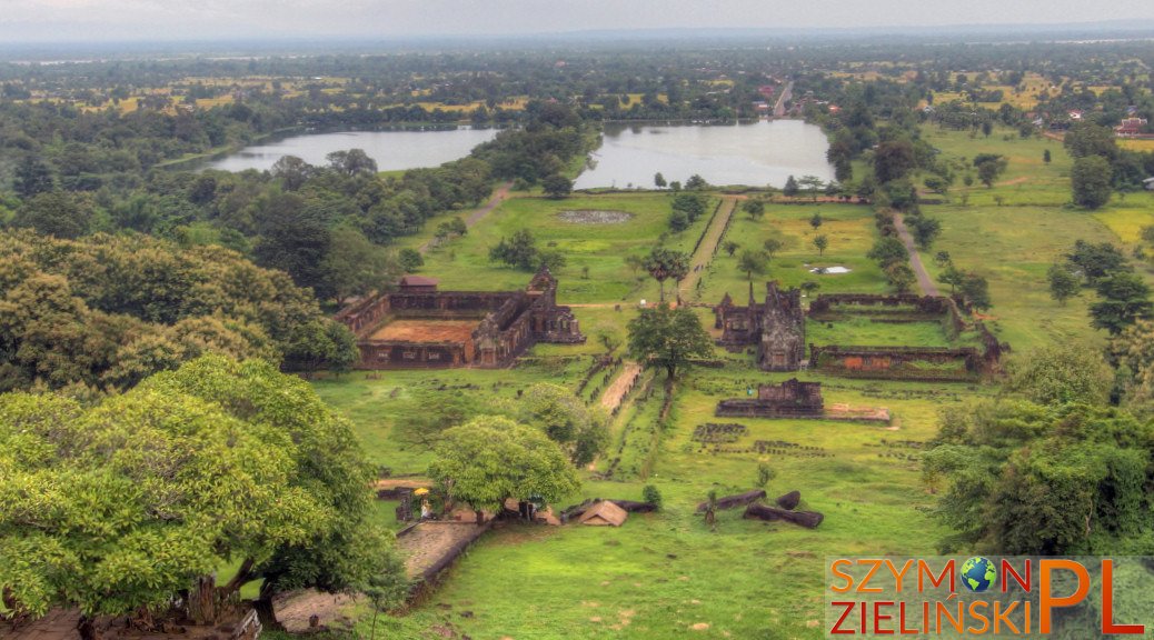
The best view of the entire Wat Phu Champasak complex.
Widok z góry na cały kompleks Wat Phu Champasak.

Wat Phu Champasak, Laos

Wat Phu Champasak, Laos

Wat Phu Champasak, Laos

Holy water spring at Wat Phu Champasak, Laos.
Źródło ze świętą wodą w Wat Phu Champasak, Laos.

Wat Phu Champasak, Laos

Let’s put those stick as a support, just in case… Wat Phu Champasak, Laos.
Podeprzemy tutaj tak na wszelki wypadek… Wat Phu Champasak, Laos.

Wat Phu Champasak, Laos

Crocodile stone at Wat Phu Champasak, Laos.
Skała “Krokodyl” w Wat Phu Champasak, Laos.

Elephant stone at Wat Phu Champasak, Laos.
Skała “Słoń” w Wat Phu Champasak, Laos.

Wat Phu Champasak, Laos

Wat Phu Champasak, Laos

Wat Phu Champasak, Laos