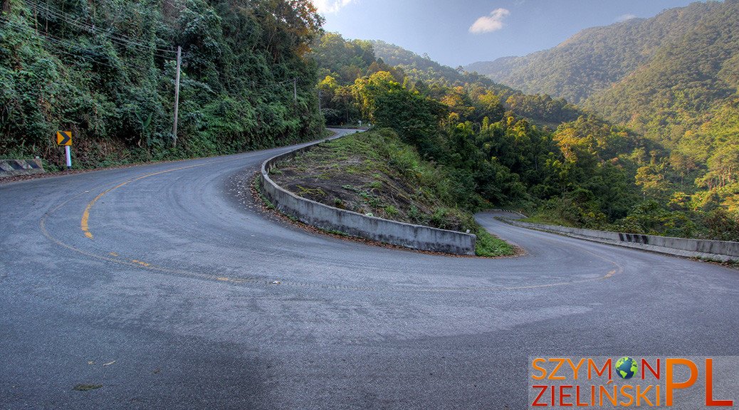
Doi Phahompok (Thai: อุทยานแห่งชาติดอยผ้าห่มปก) is the second highest mountain in Thailand (2,285 MSL) located in Chiang Mai province, not far from Fang city. It is not too popular among tourists – usually only locals go there. In order to reach the mountain top, it is necessary to use 4WD or a motorbike. The road is dirt and very challenging. One time I went up on my faithful 125 cc Honda Sonic (just take a look at photos, how dusty the road is!) and another time I went on the back of a local’s pick up truck. Outside of the season (the season goes from December until February) almost nobody comes here.
Before reaching the camp site, it is worth taking a small detour to the left, a little bit after the ticket booth (ticket for foreigners – 400 baht, about 9 euro, ticket for Thais – 40 baht, about 1 euro) in order to see the Huai Bon cave. The cave entrance is rather small, but the cave goes on for 324 m and the corridor is anything between 2 and 25 m wide. Inside the cave, one can find many interesting rock formations, not to mention the abundance of stalactites and stalagmites. There are no lights whatsoever inside the cave so it is necessary to bring your own torch (flashlight). There are few other smaller caves in the area, but there are no signs pointing their exact location. Rarely people come to visit Huai Bon cave – I was the only visitor there. After seeing the cave, it is time to move on.
By going up, we reach a camp ground – the highest in Thailand (1,924 MSL). One can easily rent a tent. During the season, there is also a working restaurant here. There is a 3.5 km trail that allows us to reach the mountain top. The trail goes up almost all the time and can be challenging for some. The park rangers said that it takes about 2 hours to reach the summit. For me, as I am an experienced hiker, it took only one hour. First time I woke up at 4 am to reach the summit for the sunrise at 6 am, but instead I have reached the peak at 5 am and I waited over one hour for the sunrise (at that time I was also the only tourist – really the only one who was spending a night there). The second time I knew that it will take me only 1 hour to reach the summit so I started my hike later.
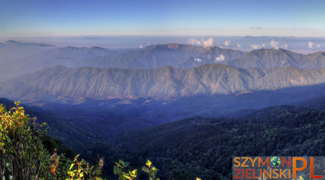
“Doi Phahompok” means “mountain with a flat top” and so it is – the top offers great views in all directions. The peak has 2,285 MSL, so in the morning we are above the clouds and the rising sun comes out of the sea of clouds. When we look to the west, we can see the border with Myanmar (Burma, and further into the country) and military outposts on the mountain tops. A little to the southwest one can see Doi Ang Khang (which I covered in the previous posts) if the weather is clear enough.
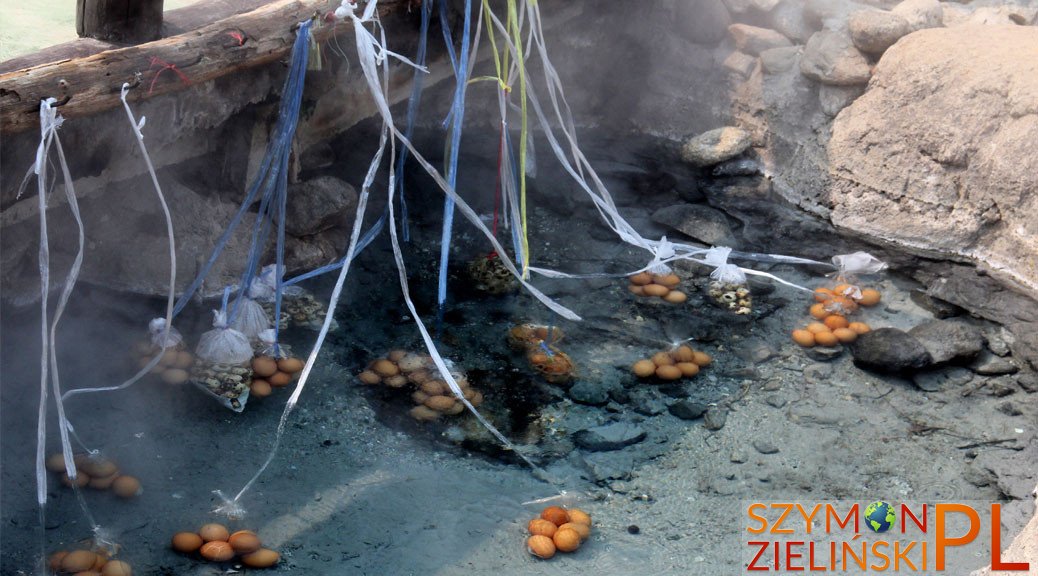
Doi Phahompok National Park offers other attractions nearby – famous hot springs and few waterfalls. I will cover these in the next post.
On the way I have made a stop at one temple, which houses the 300 year old wooden Buddha image – it is quite unique, and therefore, worth seeing.
Don’t forget to check out the second post about Doi Phahompok National Park by clicking here.
Doi Phahompok National Park (A – ticket booth, B – Kiew Lom camp ground, C – Fang hot springs)

A surprise on the road – huge rock taking one lane. On the way to Doi Phahompok, Chiang Mai province, Thailand.
Niespodzianka na drodze – wielki głaz zajmujący jeden pas ruchu. Po drodze do Doi Phahompok, prowincja Chiang Mai, Tajlandia.

A temple housing 300 year old wooden Buddha image. On the way to Doi Phahompok, Chiang Mai province, Thailand.
Świątynia przechowująca 300-letni drewniany wizerunek Buddhy. Po drodze do Doi Phahompok, prowincja Chiang Mai, Tajlandia.

300 year old wooden Buddha image. On the way to Doi Phahompok, Chiang Mai province, Thailand.
300-letni drewniany wizerunek Buddhy. Po drodze do Doi Phahompok, prowincja Chiang Mai, Tajlandia.

Dirt road to the camp site at Doi Phahompok. Doi Phahompok National Park, Chiang Mai province, Thailand.
Piaszczysta droga wiodąca na górę Doi Phahompok. Park Narodowy Doi Phahompok, prowincja Chiang Mai, Tajlandia.

Dirt road to the camp site at Doi Phahompok. Doi Phahompok National Park, Chiang Mai province, Thailand.
Piaszczysta droga wiodąca na górę Doi Phahompok. Park Narodowy Doi Phahompok, prowincja Chiang Mai, Tajlandia.

Dirt road to the camp site at Doi Phahompok. Doi Phahompok National Park, Chiang Mai province, Thailand.
Piaszczysta droga wiodąca na górę Doi Phahompok. Park Narodowy Doi Phahompok, prowincja Chiang Mai, Tajlandia.

Dirt road to the camp site at Doi Phahompok. Doi Phahompok National Park, Chiang Mai province, Thailand.
Piaszczysta droga wiodąca na górę Doi Phahompok. Park Narodowy Doi Phahompok, prowincja Chiang Mai, Tajlandia.

The steps going up to the Huai Bon cave. Doi Phahompok National Park, Chiang Mai province, Thailand.
Stopnie prowadzące do jaskini Huai Bon. Park Narodowy Doi Phahompok, prowincja Chiang Mai, Tajlandia.

Inside Huai Bon cave, near the entrance. Doi Phahompok National Park, Chiang Mai province, Thailand.
Wewnątrz jaskini Huai Bon, blisko wejścia. Park Narodowy Doi Phahompok, prowincja Chiang Mai, Tajlandia.

Inside Huai Bon cave. Doi Phahompok National Park, Chiang Mai province, Thailand.
Wewnątrz jaskini Huai Bon. Park Narodowy Doi Phahompok, prowincja Chiang Mai, Tajlandia.

Inside Huai Bon cave, just before going DEEP inside. Doi Phahompok National Park, Chiang Mai province, Thailand.
Wewnątrz jaskini Huai Bon, tuż przed wejściem w GŁĘBOKĄ część. Park Narodowy Doi Phahompok, prowincja Chiang Mai, Tajlandia.

Inside Huai Bon cave. Doi Phahompok National Park, Chiang Mai province, Thailand.
Wewnątrz jaskini Huai Bon. Park Narodowy Doi Phahompok, prowincja Chiang Mai, Tajlandia.

Inside Huai Bon cave. Doi Phahompok National Park, Chiang Mai province, Thailand.
Wewnątrz jaskini Huai Bon. Park Narodowy Doi Phahompok, prowincja Chiang Mai, Tajlandia.

Inside Huai Bon cave. Doi Phahompok National Park, Chiang Mai province, Thailand.
Wewnątrz jaskini Huai Bon. Park Narodowy Doi Phahompok, prowincja Chiang Mai, Tajlandia.

Inside Huai Bon cave. Doi Phahompok National Park, Chiang Mai province, Thailand.
Wewnątrz jaskini Huai Bon. Park Narodowy Doi Phahompok, prowincja Chiang Mai, Tajlandia.

Inside Huai Bon cave. Doi Phahompok National Park, Chiang Mai province, Thailand.
Wewnątrz jaskini Huai Bon. Park Narodowy Doi Phahompok, prowincja Chiang Mai, Tajlandia.

Inside Huai Bon cave. Doi Phahompok National Park, Chiang Mai province, Thailand.
Wewnątrz jaskini Huai Bon. Park Narodowy Doi Phahompok, prowincja Chiang Mai, Tajlandia.

Inside Huai Bon cave. Doi Phahompok National Park, Chiang Mai province, Thailand.
Wewnątrz jaskini Huai Bon. Park Narodowy Doi Phahompok, prowincja Chiang Mai, Tajlandia.

Inside Huai Bon cave. Doi Phahompok National Park, Chiang Mai province, Thailand.
Wewnątrz jaskini Huai Bon. Park Narodowy Doi Phahompok, prowincja Chiang Mai, Tajlandia.

Camp site at Doi Phahompok. Doi Phahompok National Park, Chiang Mai province, Thailand.
Pole biwakowe na Doi Phahompok. Park Narodowy Doi Phahompok, prowincja Chiang Mai, Tajlandia.

Sunset seen from the camp site. Doi Phahompok National Park, Chiang Mai province, Thailand.
Zachód słońca widziany z pola biwakowego. Park Narodowy Doi Phahompok, prowincja Chiang Mai, Tajlandia.

Sunset seen from the camp site. Doi Phahompok National Park, Chiang Mai province, Thailand.
Zachód słońca widziany z pola biwakowego. Park Narodowy Doi Phahompok, prowincja Chiang Mai, Tajlandia.

The temperature in the evening (7-8 pm). Doi Phahompok National Park, Chiang Mai province, Thailand.
Temperatura wieczorem (około godziny 19-20). Park Narodowy Doi Phahompok, prowincja Chiang Mai, Tajlandia.

Starry sky at Doi Phahompok. Doi Phahompok National Park, Chiang Mai province, Thailand.
Gwiaździste niebo nad Doi Phahompok. Park Narodowy Doi Phahompok, prowincja Chiang Mai, Tajlandia.

Starry sky at Doi Phahompok. Doi Phahompok National Park, Chiang Mai province, Thailand.
Gwiaździste niebo nad Doi Phahompok. Park Narodowy Doi Phahompok, prowincja Chiang Mai, Tajlandia.

One of the flowers. Doi Phahompok National Park, Chiang Mai province, Thailand.
Jeden z kwiatów. Park Narodowy Doi Phahompok, prowincja Chiang Mai, Tajlandia.

The views from the mountain top off the season – visibility is not as good. Doi Phahompok National Park, Chiang Mai province, Thailand.
Widoki ze szczytu poza sezonem – widoczność nie jest zbyt dobra. Park Narodowy Doi Phahompok, prowincja Chiang Mai, Tajlandia.

The views from the mountain top off the season – visibility is not as good. Doi Phahompok National Park, Chiang Mai province, Thailand.
Widoki ze szczytu poza sezonem – widoczność nie jest zbyt dobra. Park Narodowy Doi Phahompok, prowincja Chiang Mai, Tajlandia.

The path to the mountain top. Doi Phahompok National Park, Chiang Mai province, Thailand.
Ścieżka prowadząca na szczyt. Park Narodowy Doi Phahompok, prowincja Chiang Mai, Tajlandia.

The path to the mountain top. Doi Phahompok National Park, Chiang Mai province, Thailand.
Ścieżka prowadząca na szczyt. Park Narodowy Doi Phahompok, prowincja Chiang Mai, Tajlandia.

The path to the mountain top. Doi Phahompok National Park, Chiang Mai province, Thailand.
Ścieżka prowadząca na szczyt. Park Narodowy Doi Phahompok, prowincja Chiang Mai, Tajlandia.

The path to the mountain top. Some trees adopt fantastic shapes. Doi Phahompok National Park, Chiang Mai province, Thailand.
Ścieżka prowadząca na szczyt. Niektóre drzewa przybierają fantastyczne kształty. Park Narodowy Doi Phahompok, prowincja Chiang Mai, Tajlandia.

The path to the mountain top. Doi Phahompok National Park, Chiang Mai province, Thailand.
Ścieżka prowadząca na szczyt. Park Narodowy Doi Phahompok, prowincja Chiang Mai, Tajlandia.

Tourists waiting for the sunrise at the mountain top. Doi Phahompok National Park, Chiang Mai province, Thailand.
Turyści czekający na szczycie na wschód słońca. Park Narodowy Doi Phahompok, prowincja Chiang Mai, Tajlandia.

Just before the sunrise, mountains covered in the mist. You can see the mountains that make up the border with Myanmar – and further into the country. Doi Phahompok National Park, Chiang Mai province, Thailand.
Tuż przed wschodem słońca, góry skąpane we mgle. Można zobaczyć góry tworzące granicę z Mjanmą (Birmą) – i dalej w głąb kraju. Park Narodowy Doi Phahompok, prowincja Chiang Mai, Tajlandia.

Sunrise seen from the mountain top. Doi Phahompok National Park, Chiang Mai province, Thailand.
Wschód słońca widziany ze szczytu. Park Narodowy Doi Phahompok, prowincja Chiang Mai, Tajlandia.

Sunrise seen from the mountain top. Doi Phahompok National Park, Chiang Mai province, Thailand.
Wschód słońca widziany ze szczytu. Park Narodowy Doi Phahompok, prowincja Chiang Mai, Tajlandia.

Just after the sunrise, on the mountain top. You can see the mountains that make up the border with Myanmar – and further into the country. Doi Phahompok National Park, Chiang Mai province, Thailand.
Tuż po wschodzie słońca, na szczycie. Można zobaczyć góry tworzące granicę z Mjanmą (Birmą) – i dalej w głąb kraju. Park Narodowy Doi Phahompok, prowincja Chiang Mai, Tajlandia.

The path to the mountain top. Some trees adopt fantastic shapes. Doi Phahompok National Park, Chiang Mai province, Thailand.
Ścieżka prowadząca na szczyt. Niektóre drzewa przybierają fantastyczne kształty. Park Narodowy Doi Phahompok, prowincja Chiang Mai, Tajlandia.

The path to the mountain top. Doi Phahompok National Park, Chiang Mai province, Thailand.
Ścieżka prowadząca na szczyt. Park Narodowy Doi Phahompok, prowincja Chiang Mai, Tajlandia.

The path to the mountain top. Some trees adopt fantastic shapes. Doi Phahompok National Park, Chiang Mai province, Thailand.
Ścieżka prowadząca na szczyt. Niektóre drzewa przybierają fantastyczne kształty. Park Narodowy Doi Phahompok, prowincja Chiang Mai, Tajlandia.

The path to the mountain top. Some trees adopt fantastic shapes. Doi Phahompok National Park, Chiang Mai province, Thailand.
Ścieżka prowadząca na szczyt. Niektóre drzewa przybierają fantastyczne kształty. Park Narodowy Doi Phahompok, prowincja Chiang Mai, Tajlandia.

Viewpoint at the camp site. Doi Phahompok National Park, Chiang Mai province, Thailand.
Punkt widokowy na polu biwakowym. Park Narodowy Doi Phahompok, prowincja Chiang Mai, Tajlandia.

Viewpoint at the camp site. Doi Phahompok National Park, Chiang Mai province, Thailand.
Punkt widokowy na polu biwakowym. Park Narodowy Doi Phahompok, prowincja Chiang Mai, Tajlandia.

Camp site at Doi Phahompok. Doi Phahompok National Park, Chiang Mai province, Thailand.
Pole biwakowe na Doi Phahompok. Park Narodowy Doi Phahompok, prowincja Chiang Mai, Tajlandia.

Camp site at Doi Phahompok. Doi Phahompok National Park, Chiang Mai province, Thailand.
Pole biwakowe na Doi Phahompok. Park Narodowy Doi Phahompok, prowincja Chiang Mai, Tajlandia.

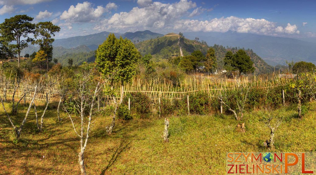
The surrounding area of Doi Phahompok. Doi Phahompok, Chiang Mai province, Thailand.
Okolice Doi Phahompok. Park Narodowy Doi Phahompok, prowincja Chiang Mai, Tajlandia.

The surrounding area of Doi Phahompok. Doi Phahompok, Chiang Mai province, Thailand.
Okolice Doi Phahompok. Park Narodowy Doi Phahompok, prowincja Chiang Mai, Tajlandia.